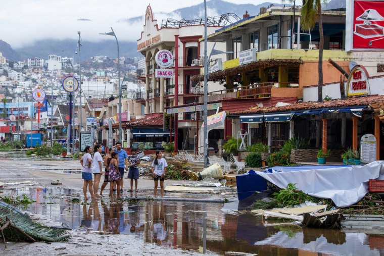
When I woke up to the devastation of Hurricane Otis — which hit Acapulco, Mexico, as a Category 5 storm and at last count had left at least 100 people dead or missing — I knew as a hurricane scientist that a “nightmare scenario” of catastrophic rapid intensification had happened. Tropical storm Otis’ winds increased by 115 mph in less than 24 hours and became a Category 5 the next day. In addition to killing so many people, the storm is believed to have caused billions of dollars in property damage and destruction just in the state of Guerrero alone.
Rapidly intensifying storms throw into disarray calculations about when or if to evacuate.
The United States has had storms rapidly intensify before making landfall, too. In 2017, Hurricane Harvey grew from a Category 1 storm with winds of 90 mph, to a Category 4 with winds of 130 mph before its first strike along the Texas coast. In 2018, Hurricane Michael’s winds intensified from 115mph to 160 mph before it hit the Florida Panhandle. Hurricane Laura’s winds strengthened from 85 mph to 150 mph before pummeling southwest Louisiana in 2020.
Rapidly intensifying storms throw into disarray calculations about when or if to evacuate. Elected officials, people running nursing homes and jails, college administrators and individual families all depend on advanced warning about destructive hurricanes. Integrated warning and preparation is our best bet at reducing harm.
But as our climate gets weirder, predicting the intensity of storms (which has always been more difficult to predict than their path) becomes even harder. And that makes preparing for or evacuating from such storms, harder, too.
Soon after the storm hit, NPR’s Eyder Peralta told host Michel Martin, “Look, up until last night, the government was preparing for a regular hurricane that would make landfall somewhere north of Acapulco. And what we have this morning is something totally different. We have a direct hit on a major Mexican city by a Category 5 hurricane.”
My question is: What exactly is a “regular” hurricane? Between where we’ve built our cities and changes in hurricane behavior, the thought that some hurricanes are just “regular” is a mentality that needs to shift.

I liken hurricane response to a complex multilayered dessert of physical understanding and human response. The weather forecast helps form the bottom layer of the cake that provides structure for the rest. But hurricane forecasting itself is a complex recipe with three main ingredients. It requires up-to-date observations of the atmosphere, especially over the ocean. Then there’s guidance from the many statistical and physical computer simulations of our atmosphere, built on our knowledge and history with hurricanes. Finally — and this is critical — there’s the knowledge, intuition and experience from human experts.
As we examine what made forecasting Otis difficult, we find reasons to appreciate the relative strength of the hurricane monitoring, forecasting and research systems we have here. The value of the NOAA and Air Force Hurricane Hunters cannot be stressed enough. In general, it’s hard to get real-time data from over the ocean. Aircraft reconnaissance is critical to grounding our estimates, especially over oceans where direct measurements are scarce. In fact, it was because of one of these monitoring flights that scientists were able to see that Hurricane Otis was defying a key satellite-based intensity estimation technique.
Hurricane Otis should cause us to examine how flexible and adaptable our preparation and response systems are to rapid changes.
Moreover, the importance of human insight cannot be overstated. When it became clear that the computers were missing the mark, human forecasters sounded the alarm.
In the hands of a skilled forecaster, all that data leads to an informed estimate of how our atmosphere will behave in coming hours, days or weeks. But, to return to the dessert-making analogy, for even the most experienced baker, a cake can unexpectedly fall. Scientists work tirelessly to reduce the frequency of such failures. Meanwhile, how do we make sure the entire emergency response dessert doesn’t collapse?
Responding to a hurricane in ways that reduce the number of lives lost and the amount of property that’s lost is complex, in large part because a hurricane itself is a huge, difficult to predict and uniquely destructive weather phenomenon. Then, on top of that, an effective government response must address socioeconomic differences in resources, mobility, information access, language and other factors. This coordination must happen at multiple societal levels and, in what needs to be a massive team effort, include numerous jurisdictions.

Hurricane Otis should cause us to examine how flexible and adaptable our preparation and response systems are to rapid changes. And it’s yet also another reminder that we need to improve how we deal with inequities.
It’s clear that government officials, researchers in emergency management and many social experts are thinking about what a storm like Otis would mean for them.
The timeline we have now about getting the coast evacuated in a two or three-day timeline ... we’re not going to have that."
New Orleans meteorologist nicondra norwood
Cynthia Lee Sheng, who is president of Jefferson Parish, Louisiana, a suburb of New Orleans, told a local television station, “There is no exercise. We’re going from a tropical storm to Cat 5 in one day. How do you evacuate an area in that amount of time?” The meteorologist for that television station, Nicondra Norwood, said, “The timeline we have now about getting the coast evacuated in a two or three-day timeline ... we’re not going to have that.”
Sheng called it “a different kind of normal that we have to brace ourselves for.”
I think of this as a new abnormal. The phenomenon of rapidly intensifying storms is something all of us need to adjust to.
